Dynamics of low-level jets in West Africa and US Great Plains and their association with precipitation variations
- The West African Westerly Jet
The West African westerly jet (WAWJ) is a low-level westerly jet located over the eastern Atlantic and the West African coast. It develops in early June, reaches a maximum intensity (about 6 m s-1 in climatology) at 925 hPa during August and dissipates in mid-October. At its mature stage, the jet extends between 12°-30°W and 8°-11°N, and from the surface to 700 hPa.
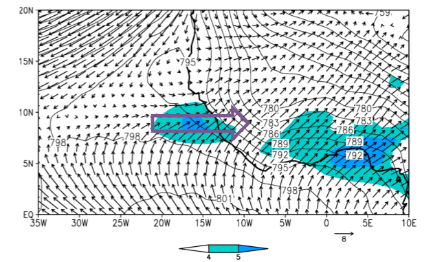
The WAWJ forms when a westerly acceleration region is generated by the superposition of the Atlantic marine ITCZ and the westward extension of the thermal low in their seasonal progression.
Variations of the WAWJ are significantly positively correlated to Sahel rainfall variations on both interannual and decadal time scales via its westward moisture transport and modulation of atmospheric moist static energy. (Pu and Cook 2010; 2012)
- The Great Plains low-level jet
The Great Plains low-level jet (GPLLJ) extends from about 20°N over the Gulf of Mexico to the northern Great Plains and Midwest, with its core located around 95°–102°W over the southern Great Plains at 850–950 hPa. It affects the variability of warm season precipitation over the central U.S. and Midwest on multiple time scales.
The GPLLJ has a strong diurnal cycle with wind speeds peak over mid-night. Using a one layer linearized boundary layer model, we found boundary layer vertical winds covary with the diurnal cycle of the GPLLJ. These oscillations are best reproduced by the model when it includes diurnal variations of both near-surface pressure gradient and surface drag.
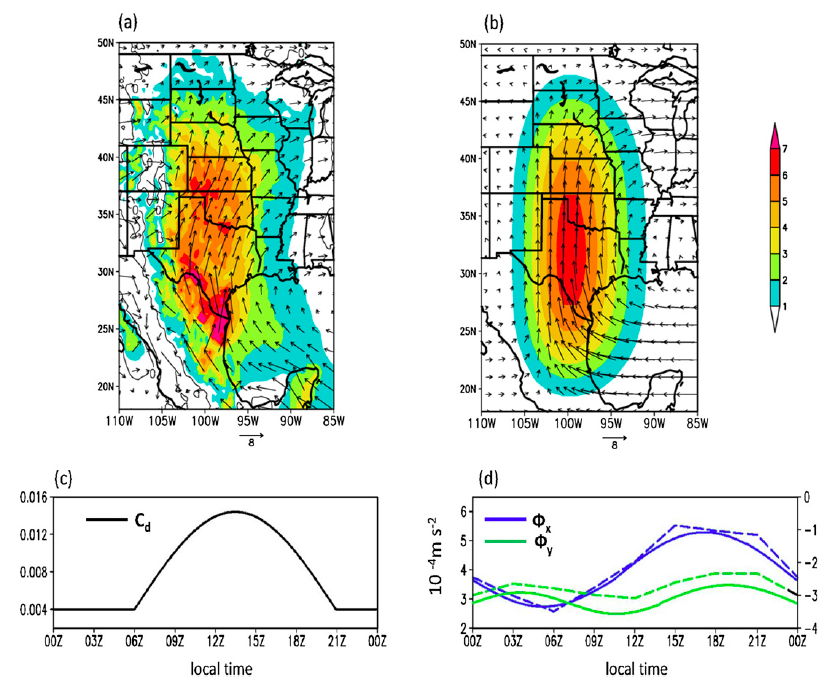
The diurnal variation of the vertical velocity (or boundary layer convergence and divergence) is explained by local vorticity balance. The slowing down of the jet after midnight decreases the anticyclonic (cyclonic) vorticity and consequently gives a positive (negative) vorticity tendency to the east (west) of the jet core; anomalous rising (sinking) motions occur to balance these positive (negative) vorticity tendencies. The pattern reverses when the jet is relatively weak. Such a development of the rising motion is consistent with the enhanced occurrence of nocturnal convective precipitation over the central and eastern Great Plains and afternoon maximum over the western Great Plains. (Pu and Dickinson 2014)
The GPLLJ also modifies low-level vorticity over the central Gulf States on the interannual time scale. Intensified southerly wind over the southern Great Plains weakens vorticity and suppresses precipitation, while the southerly inflow over the Gulf of Mexico increases precipitation over the central Gulf States via moisture transport. Thus, precipitation is large over the central Gulf States when the meridional wind over the southern Great Plains is weakest and over the Gulf of Mexico is strongest. (Pu et al. 2016a)
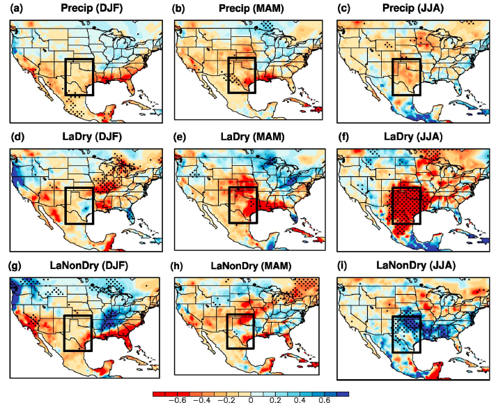
Drought development
Droughts in the Southern Great Plains (SGP) have been attributed to the cold phase of El Niño–Southern Oscillation or La Niña. While La Niña events have been clearly linked to winter droughts, their link to summer droughts has remained unclear. We analyze the difference in precipitation between dry (LaDry) and nondry (LaNonDry) summers over the SGP during La Niña years. Anomalously high geopotential height and subsidence over the SGP occur in spring, along with an intensified northward moisture flux that advects moisture away to the northern plains and Midwest. The dependence of SGP drought on La Niña is statistically significant only in winter and becomes insignificant in spring and summer. The drought development in La Niña years is related to an anomalous warming over the tropical North Atlantic in spring and an anomalous negative North Atlantic Oscillation (NAO) in summer, both of which suppress precipitation by strengthening the anomalous high over the SGP and displacing the subtropical jet streams. In years with relatively large precipitation anomalies (i.e., the 27% driest and wettest La Niña years over the SGP), up to 45% of the variances of summer precipitation can be explained by a linear combination of the Niño 3.4 sea surface temperature (SST), Pacific Decadal Oscillation (PDO), tropical North Atlantic SST, and NAO indices. An anomalously strong dry summer appears to be largely a result of a superposition of these factors. (Pu et al. 2016b)